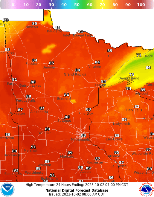
Monday will be another hot day with highs in the 80s statewide. Tuesday will again be warm ahead of a cold front that will touch off showers and thunderstorms late Tuesday with much cooler air behind it.
Record heat
It was an incredibly hot day for the first of October. Highs were in the 90s across central and southern Minnesota Sunday.

High temperatures reported Sunday, Oct. 1
National Weather Service
It’s the latest we’ve ever been above 90 degrees in the Twin Cities and a new all-time record high temperature for October.

Oct. 1 record highs
National Weather Service
Warmth continues but cooler air coming
Monday will be close to record warmth again. The record high is 89 degrees and we will likely be back in the upper 80s in the Twin Cities and across much of southern Minnesota. A few places in the west could hit 90 again.
MPR News is supported by Members. Gifts from individuals power everything you find here. Make a gift of any amount today to become a Member!

Forecast highs Monday
National Weather Service
Tuesday will still see highs in the 80s across southern Minnesota with partly cloudy skies.

Forecast highs Tuesday
National Weather Service
A cold front will touch off showers and thunderstorms later in the day in western Minnesota Tuesday and that activity will track east overnight Tuesday night.

Forecast precipitation 1 a.m. Tuesday through 7 a.m. Wednesday
National Oceanic and Atmospheric Administration, via Pivotal Weather
Behind the front, Wednesday will be considerably cooler with highs in the 70s south to just 50s north.

Forecast highs Wednesday
National Weather Service
Friday will be our coolest day yet with highs just in the 50s and 40s.

Forecast highs Friday
National Weather Service
That will set us up for a chilly night Friday night. It could be the first time the temp drops below 40 in the Twin Cities early Saturday.

Forecast lows Friday night into early Saturday
National Weather Service